
MAP OLD

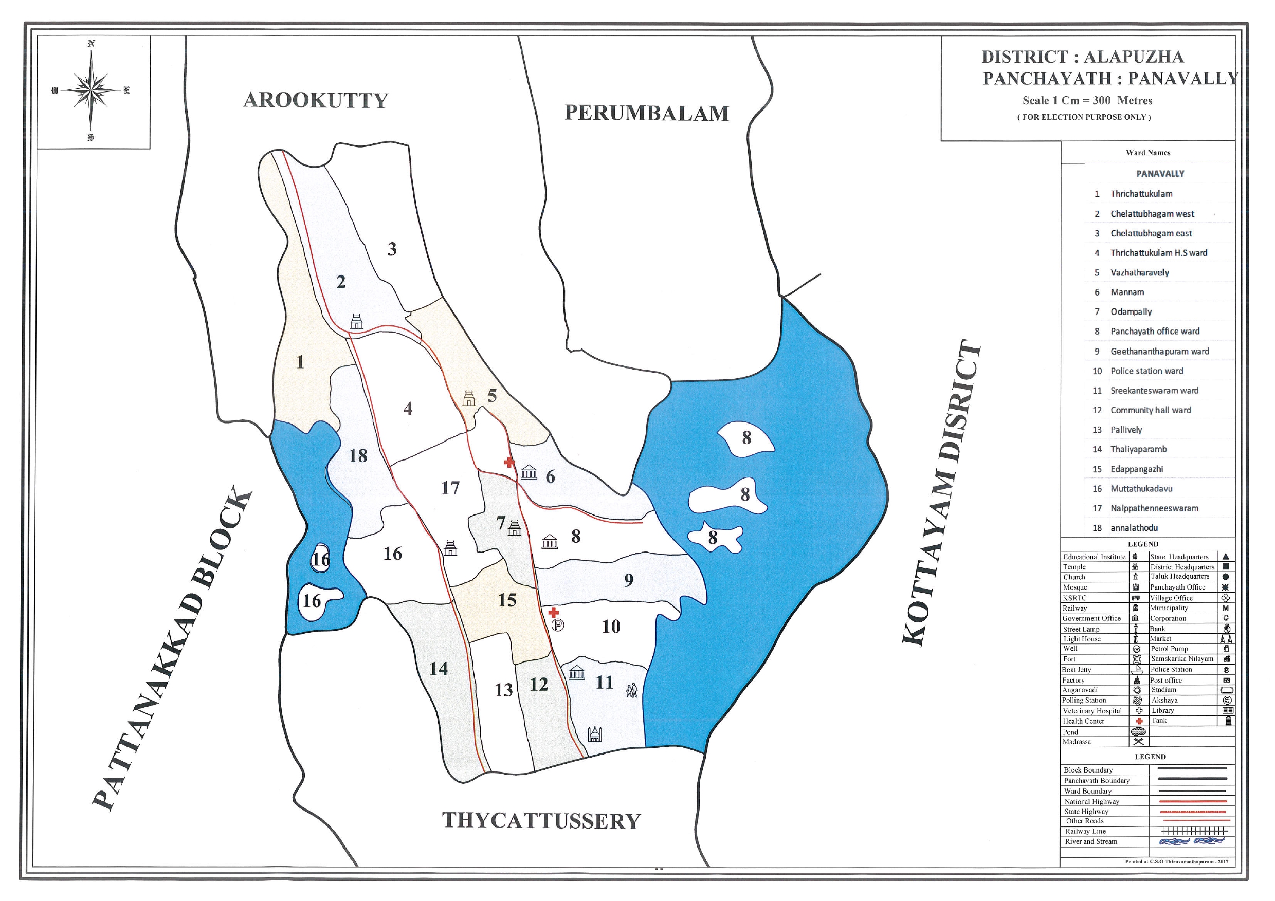
the ward delimitation map of Panavally Grama Panchayat in Alappuzha district. According to the information provided on the map, it is an official ward map prepared for election purposes.
| Information | Details |
|---|---|
| 📍 District | Alappuzha |
| 🏛 Panchayat | Panavally Grama Panchayat |
| 📏 Scale | 1 cm = 300 meters |
| 🗳 Objective | Delimitation of ward boundaries for election purposes |
The boundaries of Panavally Panchayat adjoin the following areas.
| Direction | Nearby area |
|---|---|
| ⬆️ North | Arookutty |
| ↗️North-east | Perumbalam |
| ➡️ East | The border of Kottayam district |
| ⬇️ South | Thycattussery |
| ⬅️ West | Pattanakkad Block |
Water bodies and backwater areas are widely found in the eastern and western parts of the panchayat. This indicates the region's water-dominated landscape.
According to the map, there are 18 wards in the panchayat.
📋 Names of the wards
| 1. Trichattukulam | 2. Chelattubhagam West |
| 3. Chelattubhagam East | 4. Trichattukulam HS |
| 5. Vazhatharaveli | 6. Mannam |
| 7. Odampally | 8. Panchayat Office |
| 9. Geethananthapuram | 10. Police Station Ward |
| 11. Sreekanteswaram | 12. Community Hall |
| 13. Palliveli | 14. Thaliyaparamb |
| 15. Idappangazhi | 16.Muttathukadavu |
| 17. Nalpattheeswaram | 18. Annalathodu |
⬆️ Northern region
Wards included: 1, 2, 3, 4, 5
- 🏠 Residential areas and educational institutions are primarily located here.
- 📍 It shares a border with Arookutty Panchayat.
🏛️ Central Zone
Wards included : 6, 7, 8, 9, 10, 15, 17
- 🏢 Administrative institutions such as the Panchayat office and the police station are located here.
- 📈 This area serves as the administrative and commercial hub of the panchayat.
⬇️ തെക്കൻ മേഖല
Wards included: 11, 12, 13, 14
- 🏛️ A community hall, places of worship, and public institutions are located there.
- 📍 This area is located adjacent to the Thaikkattussery region.
🌊 Water body boundary zone
Wards included: 8, 16, 18
- 🚤 Some parts of these wards are situated adjacent to water bodies and backwater areas.
- 🎣 These are areas with significant potential for fishing and backwater-based livelihoods.
Thered lines on the map indicate the major roads in the panchayat.
- 🚗 The main road connecting the panchayat in a north-south direction.
- ➡️ A road network extending eastwards from the central area.
- 🏫 Excellent road connectivity to educational and administrative institutions.
| 🏫 Educational institutions | 🛕 Temples |
| ⛪ Church | 👮 Police station |
| 🏛️ Panchayat Office | 🏢 Community Hall |
| 🏥 Healthcare institutions | 📚 Library |
| 🏦 Bank | 📮 Post Office |
ℹ️Key Observation
Administrative institutions are primarily concentrated in the central area comprising Wards 6 to 12.
✅ Forces
- 🌊 Backwater areas suitable for water transportation and fishing.
- 🏛️ Presence of administrative facilities in the central area.
- 🛣️ A main road network connects all the wards.
- 🏫 Excellent distribution of educational and social institutions.
📌 Assessment
The balanced presence of administrative facilities, transportation systems, educational institutions, and water resources creates excellent prospects for the future development of Panavally Grama Panchayat.